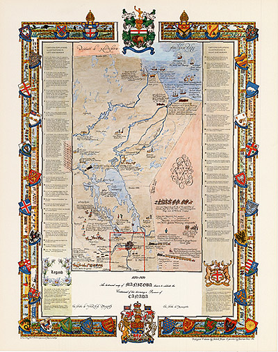
The Manitoba Historical Map
This is a beautiful historical map of Manitoba
drawn to celebrate
the centennial of her becoming a Province of Canada.
It shows the Coat of Arms of many of the early
countries that helped
populate the various regions of Manitoba.The shields in the border
also show typical beadwork of the Manitoba Indians important to
our province.
There are captions explaining its important history
illustrated on both sides of the border.
The Manitoba Historical Map displays nearly 400
years of Manitoba History. This decorative ART PIECE took 2 International
Printing Awards. It is a true delight to experience and enjoy
our history and the magnificence of our Province.
You can now own one of these Manitoba Historical
Maps that you will treasure for many years. It measures 23”x29”.
It is BIG and beautiful.
They are available from FDI - Fundraising Development
International LTD at
only $40.00 each plus 5% GST and 7% PST and $10.00
postage and handling.
Get yours today while the limited supply lasts!
Funds raised from the sale of this
item will be used to forward the
Manitoba Neighbours legacy book project!
Back